| Citation: | Li Jun, Peng Suping, Zhang Chengye, Yang Fei, Sang Xiao. Quantitative remote sensing-based monitoring and evaluation of the ecological environment in mining areas: technology framework and application[J]. Journal of Mining Science and Technology, 2022, 7(1): 9-25, 88. doi: 10.19606/j.cnki.jmst.2022.01.002

|

| [1] |
中华人民共和国自然资源部. 中国矿产资源报告2020[EB/OL]. (2020-10-22)[2020-11-24]. http://www.mnr.gov.cn/sj/sjfw/kc_19263/zgkczybg/202010/t20201022_2572964.
|
| [2] |
中国煤炭工业协会. 2020煤炭行业发展年度报告[EB/OL]. (2021-03-03)[2021-08-01]. http://www.coalchina.org.cn/uploadfile/2021/0303/20210303022435291.
|
| [3] |
毕银丽, 彭苏萍, 杜善周. 西部干旱半干旱露天煤矿生态重构技术难点及发展方向[J]. 煤炭学报, 2021, 46(5): 1355-1364. https://www.cnki.com.cn/Article/CJFDTOTAL-MTXB202105002.htm
Bi Yinli, Peng Suping, Du Shanzhou. Technological difficulties and future directions of ecological reconstruction in open pit coal mine of the arid and semi-arid areas of Western China[J]. Journal of China Coal Society, 2021, 46(5): 1355-1364. https://www.cnki.com.cn/Article/CJFDTOTAL-MTXB202105002.htm
|
| [4] |
汪云甲. 矿区生态扰动监测研究进展与展望[J]. 测绘学报, 2017, 46(10): 1705-1716. doi: 10.11947/j.AGCS.2017.20170358
Wang Yunjia. Research progress and prospect on ecological disturbance monitoring in mining area[J]. Acta Geodaetica et Cartographica Sinica, 2017, 46(10): 1705-1716. doi: 10.11947/j.AGCS.2017.20170358
|
| [5] |
刘善军, 王植, 毛亚纯, 等. 矿山安全与环境的多源遥感监测技术[J]. 测绘与空间地理信息, 2015, 38(10): 98-100. doi: 10.3969/j.issn.1672-5867.2015.10.031
Liu Shanjun, Wang Zhi, Mao Yachun, et al. Multi-source remote sensing technology for monitoring safety and environment in mine[J]. Geomatics & Spatial Information Technology, 2015, 38(10): 98-100. doi: 10.3969/j.issn.1672-5867.2015.10.031
|
| [6] |
王双明, 杜华栋, 王生全. 神木北部采煤塌陷区土壤与植被损害过程及机理分析[J]. 煤炭学报, 2017, 42(1): 17-26.
Wang Shuangming, Du Huadong, Wang Shengquan. Analysis of damage process and mechanism for plant community and soil properties at northern Shenmu subsidence mining area[J]. Journal of China Coal Society, 2017, 42(1): 17-26.
|
| [7] |
刘英. 半干旱煤矿区受损植被引导型恢复研究[D]. 徐州: 中国矿业大学, 2020.
|
| [8] |
马守臣, 马守田, 邵云, 等. 矿井废水灌溉对小麦生理特性及重金属积累的影响[J]. 应用生态学报, 2013, 24(11): 3243-3248.
Ma Shouchen, Ma Shoutian, Shao Yun, et al. Effects of irrigation with mine wastewater on physiological characters and heavy metals accumulation of winter wheat[J]. Chinese Journal of Applied Ecology, 2013, 24(11): 3243-3248.
|
| [9] |
范立民, 向茂西, 彭捷, 等. 西部生态脆弱矿区地下水对高强度采煤的响应[J]. 煤炭学报, 2016, 41(11): 2672-2678. https://www.cnki.com.cn/Article/CJFDTOTAL-MTXB201611003.htm
Fan Limin, Xiang Maoxi, Peng Jie, et al. Groundwater response to intensive mining in ecologically fragile area[J]. Journal of China Coal Society, 2016, 41(11): 2672-2678. https://www.cnki.com.cn/Article/CJFDTOTAL-MTXB201611003.htm
|
| [10] |
骆占斌. 黄土高原矿区采煤扰动后土壤微生物群落结构变化及驱动机制研究[D]. 徐州: 中国矿业大学, 2019.
|
| [11] |
杨志文, 刘文锴, 胡青峰, 等. 煤矿开采沉陷对地表土壤水分的影响研究[J]. 华北水利水电大学学报: 自然科学版, 2020, 41(5): 53-59, 72. https://www.cnki.com.cn/Article/CJFDTOTAL-HBSL202005009.htm
Yang Zhiwen, Liu Wenkai, Hu Qingfeng, et al. Study on the influence of coal mining subsidence on surface soil moisture[J]. Journal of North China University of Water Resources and Electric Power: Natural Science Edition, 2020, 41(5): 53-59, 72. https://www.cnki.com.cn/Article/CJFDTOTAL-HBSL202005009.htm
|
| [12] |
张昊然. 典型煤矸石堆积区土壤中重金属空间分布及迁移规律研究[D]. 西安: 西安科技大学, 2020.
|
| [13] |
Li J, Pei Y Q, Zhao S H, et al. A review of remote sensing for environmental monitoring in China[J]. Remote Sensing, 2020, 12(7): 1130. doi: 10.3390/rs12071130
|
| [14] |
李军, 董恒, 王祥, 等. 基于最优插值的土壤含水量遥感反演缺失数据插补[J]. 国土资源遥感, 2018, 30(2): 45-52. https://www.cnki.com.cn/Article/CJFDTOTAL-GTYG201802006.htm
Li Jun, Dong Heng, Wang Xiang, et al. Reconstructing missing data in soil moisture content derived from remote sensing based on optimum interpolation[J]. Remote Sensing for Land & Resources, 2018, 30(2): 45-52. https://www.cnki.com.cn/Article/CJFDTOTAL-GTYG201802006.htm
|
| [15] |
杜培军, 郑辉, 张海荣. 矿业/矿区发展空间信息技术保障体系研究进展与若干关键技术[J]. 科技导报, 2007, 25(9): 52-59. doi: 10.3321/j.issn:1000-7857.2007.09.012
Du Peijun, Zheng Hui, Zhang Hairong. Spatial information technology-based supporting system for the development of mining industry and mining areas: research progress and several key techniques[J]. Science & Technology Review, 2007, 25(9): 52-59. doi: 10.3321/j.issn:1000-7857.2007.09.012
|
| [16] |
Werner T T, Mudd G M, Schipper A M, et al. Global-scale remote sensing of mine areas and analysis of factors explaining their extent[J]. Global Environmental Change-Human and Policy Dimensions, 2020, 60: 102007. doi: 10.1016/j.gloenvcha.2019.102007
|
| [17] |
Sabins F F. Remote sensing for mineral exploration[J]. Ore Geology Reviews, 1999, 14(3/4): 157-183. http://www.sciencedirect.com/science/article/pii/S0169136899000074
|
| [18] |
Suh J, Kim S M, Yi H, et al. An overview of GIS-based modeling and assessment of mining-induced hazards: soil, water, and forest[J]. International Journal of Environmental Research and Public Health, 2017, 14(12): 1463. doi: 10.3390/ijerph14121463
|
| [19] |
韩福顺. 集成星地观测与动力学模型的煤矿区资源环境承载状态评价和仿真预测[D]. 徐州: 中国矿业大学, 2018.
|
| [20] |
胡召玲, 杜培军, 赵昕. 徐州煤矿区土地利用变化分析[J]. 地理学报, 2007, 62(11): 1204-1214. https://www.cnki.com.cn/Article/CJFDTOTAL-DLXB200711012.htm
Hu Zhaoling, Du Peijun, Zhao Xin. Land use changes in Xuzhou coal mining area[J]. Acta Geographica Sinica, 2007, 62(11): 1204-1214. https://www.cnki.com.cn/Article/CJFDTOTAL-DLXB200711012.htm
|
| [21] |
尘福艳, 郭仲皓, 张英海, 等. 基于遥感与GIS技术的陕北煤矿区生态环境质量评价: 以杨伙盘矿区为例[J]. 中国煤炭, 2020, 46(6): 45-51. doi: 10.3969/j.issn.1006-530X.2020.06.010
Chen Fuyan, Guo Zhonghao, Zhang Yinghai, et al. Evaluation of ecological environment quality of northern Shaanxi mining area based on remote sensing and GIS technology—taking Yanghuopan mining area as an example[J]. China Coal, 2020, 46(6): 45-51. doi: 10.3969/j.issn.1006-530X.2020.06.010
|
| [22] |
Yang Z F, Li Z W, Zhu J J, et al. Locating and defining underground goaf caused by coal mining from space-borne SAR interferometry[J]. ISPRS Journal of Photogrammetry and Remote Sensing, 2018, 135: 112-126. doi: 10.1016/j.isprsjprs.2017.11.020
|
| [23] |
肖武, 胡振琪, 张建勇, 等. 无人机遥感在矿区监测与土地复垦中的应用前景[J]. 中国矿业, 2017, 26(6): 71-78. doi: 10.3969/j.issn.1004-4051.2017.06.014
Xiao Wu, Hu Zhenqi, Zhang Jianyong, et al. The status and prospect of UAV remote sensing in mine monitoring and land reclamation[J]. China Mining Magazine, 2017, 26(6): 71-78. doi: 10.3969/j.issn.1004-4051.2017.06.014
|
| [24] |
中华人民共和国环境保护部. 中华人民共和国环保行业标准: 生态环境状况评价技术规范HJ 192—2015[S]. 北京: 中国环境科学出版社, 2015.
|
| [25] |
徐凯磊, 胡智峰, 丁建伟, 等. 基于多时相遥感影像的蔚县矿区环境评价[J]. 煤炭技术, 2020, 39(6): 149-153.
Xu Kailei, Hu Zhifeng, Ding Jianwei, et al. Quantitative evaluation of ecological environment in Yuxian County coalfield based on multi-temporal RS imagery[J]. Coal Technology, 2020, 39(6): 149-153.
|
| [26] |
张汉. 矿山地质环境评价指标体系与综合评价[D]. 北京: 中国地质大学(北京), 2020.
|
| [27] |
朱冬雨, 陈涛, 牛瑞卿, 等. 利用移动窗口遥感生态指数分析矿区生态环境[J]. 武汉大学学报: 信息科学版, 2021, 46(3): 341-347. https://www.cnki.com.cn/Article/CJFDTOTAL-WHCH202103005.htm
Zhu Dongyu, Chen Tao, Niu Ruiqing, et al. Analyzing the ecological environment of mining area by using moving window remote sensing ecological index[J]. Geomatics and Information Science of Wuhan University, 2021, 46(3): 341-347. https://www.cnki.com.cn/Article/CJFDTOTAL-WHCH202103005.htm
|
| [28] |
王佳奇, 卢明银, 王庆雄, 等. 基于熵权法-云模型保水开采生态环境评价研究[J/OL]. 煤炭科学技术, 1-8[2021-01-17]. http://kns.cnki.net/kcms/detail/11.2402.TD.20200929.1205.002.html.
Wang Jiaqi, Lu Mingyin, Wang Qingxiong, et al. Study on ecological environment assessment of water conservation mining based on entropy weight method and cloud model[J/OL]. Coal Science and Technology, 1-8[2021-01-17]. http://kns.cnki.net/kcms/detail/11.2402.TD.20200929.1205.002.html.
|
| [29] |
吴振华. 基于3S集成技术的半干旱草原区大型露天煤炭基地景观格局优化研究[D]. 徐州: 中国矿业大学, 2020.
|
| [30] |
彭苏萍, 毕银丽. 黄河流域煤矿区生态环境修复关键技术与战略思考[J]. 煤炭学报, 2020, 45(4): 1211-1221.
Peng Suping, Bi Yinli. Strategic consideration and core technology about environmental ecological restoration in coal mine areas in the Yellow River Basin of China[J]. Journal of China Coal Society, 2020, 45(4): 1211-1221.
|
| [31] |
陈建平, 张莹, 王江霞, 等. 中国铜矿现状及潜力分析[J]. 地质学刊, 2013, 37(3): 358-365. doi: 10.3969/j.issn.1674-3636.2013.03.358
Chen Jianping, Zhang Ying, Wang Jiangxia, et al. On present situation and potential analysis of copper resources in China[J]. Journal of Geology, 2013, 37(3): 358-365. doi: 10.3969/j.issn.1674-3636.2013.03.358
|
| [32] |
郑民, 李建忠, 吴晓智, 等. 我国主要含油气盆地油气资源潜力及未来重点勘探领域[J]. 地球科学, 2019, 44(3): 833-847.
Zheng Min, Li Jianzhong, Wu Xiaozhi, et al. Potential of oil and natural gas resources of main hydrocarbon-bearing basins and key exploration fields in China[J]. Earth Science, 2019, 44(3): 833-847.
|
| [33] |
李春风, 柳振江, 王建平, 等. 我国铝矿资源现状分析及可持续发展建议[J]. 中国矿业, 2014, 23(8): 5-10. doi: 10.3969/j.issn.1004-4051.2014.08.002
Li Chunfeng, Liu Zhenjiang, Wang Jianping, et al. Current status and sustainable development of aluminum resources in China[J]. China Mining Magazine, 2014, 23(8): 5-10. doi: 10.3969/j.issn.1004-4051.2014.08.002
|
| [34] |
赵立群, 王春女, 张敏, 等. 中国铁矿资源勘查开发现状及供需形势分析[J]. 地质与勘探, 2020, 56(3): 635-643.
Zhao Liqun, Wang Chunnü, Zhang Min, et al. Current exploration status and supply-demand situation of iron ore resources in China mainland[J]. Geology and Exploration, 2020, 56(3): 635-643.
|
| [35] |
郝成元, 马守臣, 聂小军. 矿区生态系统康复与生态文明建设[M]. 北京: 科学出版社, 2017: 3-6.
|
| [36] |
王永炜. 中国煤炭资源分布现状和远景预测[J]. 煤, 2007, 16(5): 44-45.
Wang Yongwei. Current situation and future forecast of coal resources distribution in China[J]. Coal, 2007, 16(5): 44-45.
|
| [37] |
Farjana S H, Huda N, Parvez M A, et al. A review on the impact of mining and mineral processing industries through life cycle assessment[J]. Journal of Cleaner Production, 2019, 231: 1200-1217. doi: 10.1016/j.jclepro.2019.05.264
|
| [38] |
张延旭, 毕银丽, 王志刚, 等. 采煤塌陷对毛乌素沙地油蒿(Artemisia ordosica)根际环境影响[J]. 矿业科学学报, 2016, 1(2): 131-139. http://kykxxb.cumtb.edu.cn/article/id/19
Zhang Yanxu, Bi Yinli, Wang Zhigang, et al. Effects of coal mining subsidence on the rhizosphere environment of Artemisia ordosica in Mu Us sandland, northwest China[J]. Journal of Mining Science and Technology, 2016, 1(2): 131-139. http://kykxxb.cumtb.edu.cn/article/id/19
|
| [39] |
戴华阳. 岩层与地表移动变形量的时空关系及描述方法[J]. 煤炭学报, 2018, 43(S2): 450-459. https://www.cnki.com.cn/Article/CJFDTOTAL-MTXB2018S2013.htm
Dai Huayang. Mining subsidence variables and their time-space relationship description[J]. Journal of China Coal Society, 2018, 43(S2): 450-459. https://www.cnki.com.cn/Article/CJFDTOTAL-MTXB2018S2013.htm
|
| [40] |
Townsend P A, Helmers D P, Kingdon C C, et al. Changes in the extent of surface mining and reclamation in the Central Appalachians detected using a 1976—2006 Landsat time series[J]. Remote Sensing of Environment, 2009, 113(1): 62-72. doi: 10.1016/j.rse.2008.08.012
|
| [41] |
Demirel N, Emil M K, Duzgun H S. Surface coal mine area monitoring using multi-temporal high-resolution satellite imagery[J]. International Journal of Coal Geology, 2011, 86(1): 3-11. doi: 10.1016/j.coal.2010.11.010
|
| [42] |
Li J, Zipper C E, Donovan P F, et al. Reconstructing disturbance history for an intensively mined region by time-series analysis of Landsat imagery[J]. Environmental Monitoring and Assessment, 2015, 187(9): 557. doi: 10.1007/s10661-015-4766-1
|
| [43] |
Soulard C E, Acevedo W, Stehman S V, et al. Mapping extent and change in surface mines within the United States for 2001 to 2006[J]. Land Degradation & Development, 2016, 27(2): 248-257. http://www.onacademic.com/detail/journal_1000039192110010_1491.html
|
| [44] |
LaJeunesse Connette K, Connette G, Bernd A, et al. Assessment of mining extent and expansion in Myanmar based on freely-available satellite imagery[J]. Remote Sensing, 2016, 8(11): 912. doi: 10.3390/rs8110912
|
| [45] |
何芳, 徐友宁, 乔冈, 等. 中国矿山环境地质问题区域分布特征[J]. 中国地质, 2010, 37(5): 1520-1529. doi: 10.3969/j.issn.1000-3657.2010.05.028
He Fang, Xu Youning, Qiao Gang, et al. Regional distribution characteristics of mine environmental geological problems in China[J]. Geology in China, 2010, 37(5): 1520-1529. doi: 10.3969/j.issn.1000-3657.2010.05.028
|
| [46] |
Gabr S, Ghulam A, Kusky T. Detecting areas of high-potential gold mineralization using ASTER data[J]. Ore Geology Reviews, 2010, 38(1/2): 59-69. http://www.sciencedirect.com/science/article/pii/S0169136810000600
|
| [47] |
林丽新, 汪云甲, 熊集兵. 煤矿塌陷地水体叶绿素a高光谱监测进展与挑战[J]. 金属矿山, 2013(6): 143-147, 150. doi: 10.3969/j.issn.1001-1250.2013.06.039
Lin Lixin, Wang Yunjia, Xiong Jibing. Advances and challenges in water chlorophyll-a monitoring by hyperspectral remote sensing in a coal mine subsidence area[J]. Metal Mine, 2013(6): 143-147, 150. doi: 10.3969/j.issn.1001-1250.2013.06.039
|
| [48] |
夏清, 胡振琪. 多光谱遥感影像煤火监测新方法[J]. 光谱学与光谱分析, 2016, 36(8): 2712-2720. https://www.cnki.com.cn/Article/CJFDTOTAL-GUAN201608071.htm
Xia Qing, Hu Zhenqi. A novel method to monitor coal fires based on multi-spectral landsat images[J]. Spectroscopy and Spectral Analysis, 2016, 36(8): 2712-2720. https://www.cnki.com.cn/Article/CJFDTOTAL-GUAN201608071.htm
|
| [49] |
Shen X Y, Hong Y, Qin Q M, et al. Orientation angle calibration for bare soil moisture estimation using fully polarimetric SAR data[J]. IEEE Transactions on Geoscience and Remote Sensing, 2011, 49(12): 4987-4996. doi: 10.1109/TGRS.2011.2158583
|
| [50] |
王行风, 韩宝平, 汪云甲, 等. 基于遥感的煤矿区景观生态分类[J]. 辽宁工程技术大学学报, 2007, 26(5): 776-779. doi: 10.3969/j.issn.1008-0562.2007.05.041
Wang Xingfeng, Han Baoping, Wang Yunjia, et al. Landscape eco-classification in mining area based on RS[J]. Journal of Liaoning Technical University, 2007, 26(5): 776-779. doi: 10.3969/j.issn.1008-0562.2007.05.041
|
| [51] |
李恒凯, 肖松松, 王秀丽, 等. 基于Mask R-CNN的高分遥感影像的稀土开采识别方法[J]. 中国矿业大学学报, 2020, 49(6): 1215-1222.
Li Hengkai, Xiao Songsong, Wang Xiuli, et al. High-resolution remote sensing image rare earth mining identification method based on Mask R-CNN[J]. Journal of China University of Mining & Technology, 2020, 49(6): 1215-1222.
|
| [52] |
宋亮, 刘善军, 虞茉莉, 等. 基于可见-近红外和热红外光谱联合分析的煤和矸石分类方法研究[J]. 光谱学与光谱分析, 2017, 37(2): 416-422. https://www.cnki.com.cn/Article/CJFDTOTAL-GUAN201702020.htm
Song Liang, Liu Shanjun, Yu Moli, et al. A classification method based on the combination of visible, near-infrared and thermal infrared spectrum for coal and gangue distinguishment[J]. Spectroscopy and Spectral Analysis, 2017, 37(2): 416-422. https://www.cnki.com.cn/Article/CJFDTOTAL-GUAN201702020.htm
|
| [53] |
Zhang C Y, Yue J, Qin Q M. Global prototypical network for few-shot hyperspectral image classification[J]. IEEE Journal of Selected Topics in Applied Earth Observations and Remote Sensing, 2020, 13: 4748-4759. doi: 10.1109/JSTARS.2020.3017544
|
| [54] |
Zhang C Y, Yue J, Qin Q M. Deep quadruplet network for hyperspectral image classification with a small number of samples[J]. Remote Sensing, 2020, 12(4): 647. doi: 10.3390/rs12040647
|
| [55] |
贾臣, 孙林, 陈允芳, 等. 深度置信网络算法反演Landsat 8 OLI气溶胶光学厚度[J]. 遥感学报, 2020, 24(10): 1180-1192. https://www.cnki.com.cn/Article/CJFDTOTAL-YGXB202010003.htm
Jia Chen, Sun Lin, Chen Yunfang, et al. Inversion of aerosol optical depth for Landsat 8 OLI data using deep belief network[J]. Journal of Remote Sensing, 2020, 24(10): 1180-1192. https://www.cnki.com.cn/Article/CJFDTOTAL-YGXB202010003.htm
|
| [56] |
张雪, 郑小慎. 基于BP神经网络渤海湾表层叶绿素浓度反演方法探讨[J]. 海洋技术学报, 2018, 37(6): 79-87.
Zhang Xue, Zheng Xiaoshen. Discussion on retrieval method of surface chlorophyll concentration of the Bohai bay based on BP neural network[J]. Journal of Ocean Technology, 2018, 37(6): 79-87.
|
| [57] |
Sonobe R, Hirono Y, Oi A. Quantifying chlorophyll-a and b content in tea leaves using hyperspectral reflectance and deep learning[J]. Remote Sensing Letters, 2020, 11(10): 933-942. doi: 10.1080/2150704X.2020.1795294
|
| [58] |
郑小坡, 孙越君, 秦其明, 等. 基于可见光-短波红外波谱反射率的裸土土壤含水量反演建模[J]. 光谱学与光谱分析, 2015, 35(8): 2113-2118. doi: 10.3964/j.issn.1000-0593(2015)08-2113-06
Zheng Xiaopo, Sun Yuejun, Qin Qiming, et al. Bare soil moisture inversion model based on visible-shortwave infrared reflectance[J]. Spectroscopy and Spectral Analysis, 2015, 35(8): 2113-2118. doi: 10.3964/j.issn.1000-0593(2015)08-2113-06
|
| [59] |
王启元, 赵艳玲, 房铄东, 等. 基于多光谱遥感的裸土土壤含水量反演研究[J]. 矿业科学学报, 2020, 5(6): 608-615. doi: 10.19606/j.cnki.jmst.2020.06.002
Wang Qiyuan, Zhao Yanling, Fang Shuodong, et al. Inversion of soil moisture in bare soil based on multi-spectral remote sensing[J]. Journal of Mining Science and Technology, 2020, 5(6): 608-615. doi: 10.19606/j.cnki.jmst.2020.06.002
|
| [60] |
Tan Kun, Ye Yuanyuan, Du Peijun, et al. Estimation of heavy metal concentrations in reclaimed mining soils using reflectance spectroscopy[J]. 光谱学与光谱分析, 2014, 34(12): 3317-3322. doi: 10.3964/j.issn.1000-0593(2014)12-3317-06
Tan Kun, Ye Yuanyuan, Du Peijun, et al. Estimation of heavy metal concentrations in reclaimed mining soils using reflectance spectroscopy[J]. Spectroscopy and Spectral Analysis, 2014, 34(12): 3317-3322. doi: 10.3964/j.issn.1000-0593(2014)12-3317-06
|
| [61] |
毕银丽, 孙江涛, Ypyszhan Zhakypbek, 等. 不同施磷水平下接种菌根玉米营养状况及光谱特征分析[J]. 煤炭学报, 2016, 41(5): 1227-1235.
Bi Yinli, Sun Jiangtao, Zhakypbek Y, et al. Hyperspectral characterization and nutrition condition of maize inoculated with arbuscular mycorrhiza in different phosphorus levels[J]. Journal of China Coal Society, 2016, 41(5): 1227-1235.
|
| [62] |
陈书琳, 毕银丽. 遥感技术在微生物复垦中的应用研究[J]. 国土资源遥感, 2014, 26(3): 16-23.
Chen Shulin, Bi Yinli. Application of remote sensing technology to microbial reclamation[J]. Remote Sensing for Land & Resources, 2014, 26(3): 16-23.
|
| [63] |
卞正富, 雷少刚, 常鲁群, 等. 基于遥感影像的荒漠化矿区土壤含水率的影响因素分析[J]. 煤炭学报, 2009, 34(4): 520-525. doi: 10.3321/j.issn:0253-9993.2009.04.018
Bian Zhengfu, Lei Shaogang, Chang Luqun, et al. Affecting factors analysis of soil moisture for arid mining area based on TM images[J]. Journal of China Coal Society, 2009, 34(4): 520-525. doi: 10.3321/j.issn:0253-9993.2009.04.018
|
| [64] |
徐霞, 孙文彬, 王振. 基于TVDI的布尔台矿区土壤湿度变化分析[J]. 矿业科学学报, 2019, 4(4): 285-291. http://kykxxb.cumtb.edu.cn/article/id/225
Xu xia, Sun Wenbin, Wang Zhen. Analysis of soil moisture changes of the Buertai mining area based on TVDI[J]. Journal of Mining Science and Technology, 2019, 4(4): 285-291. http://kykxxb.cumtb.edu.cn/article/id/225
|
| [65] |
赵东发. 基于IEM模型的双极化TerraSAR数据反演土壤水分: 以大柳塔矿为例[D]. 徐州: 中国矿业大学, 2015.
|
| [66] |
李军, 桑潇, 张成业, 等. 资源型城市长时间序列土壤含水量变化分析: 以锡林浩特市为例[J]. 测绘通报, 2021(7): 17-22, 38.
Li Jun, Sang Xiao, Zhang Chengye, et al. Analysis of soil moisture content changes in resource-based cities over a long time series: a case study of Xilinhot city[J]. Bulletin of Surveying and Mapping, 2021(7): 17-22, 38.
|
| [67] |
Zhang C Y, Ren H Z, Liang Y Z, et al. Advancing the Prospect-5 model to simulate the spectral reflectance of copper-stressed leaves[J]. Remote Sensing, 2017, 9(11): 1191. doi: 10.3390/rs9111191
|
| [68] |
肖武, 张文凯, 吕雪娇, 等. 西部生态脆弱区矿山不同开采强度下生态系统服务时空变化: 以神府矿区为例[J]. 自然资源学报, 2020, 35(1): 68-81. https://www.cnki.com.cn/Article/CJFDTOTAL-ZRZX202001007.htm
Xiao Wu, Zhang Wenkai, Lü Xuejiao, et al. Spatio-temporal patterns of ecological capital under different mining intensities in an ecologically fragile mining area in Western China: a case study of Shenfu mining area[J]. Journal of Natural Resources, 2020, 35(1): 68-81. https://www.cnki.com.cn/Article/CJFDTOTAL-ZRZX202001007.htm
|
| [69] |
雷少刚. 荒漠矿区关键环境要素的监测与采动影响规律研究[D]. 徐州: 中国矿业大学, 2009.
|
| [70] |
毕如田, 白中科, 李华, 等. 大型露天煤矿区土地扰动的时空变化[J]. 应用生态学报, 2007, 18(8): 1908-1912.
Bi Rutian, Bai Zhongke, Li Hua, et al. Spatiotemporal variation of land disturbance on large opencast coal mine area[J]. Chinese Journal of Applied Ecology, 2007, 18(8): 1908-1912.
|
| [71] |
李晶, 邓晓娟, 杨震, 等. 基于时序多光谱影像的干旱草原区开采扰动信息提取方法[J]. 光谱学与光谱分析, 2019, 39(12): 3788-3793.
Li Jing, Deng Xiaojuan, Yang Zhen, et al. A method of extracting mining disturbance in arid grassland based on time series multispectral images[J]. Spectroscopy and Spectral Analysis, 2019, 39(12): 3788-3793.
|
| [72] |
Charou E, Stefouli M, Dimitrakopoulos D, et al. Using remote sensing to assess impact of mining activities on land and water resources[J]. Mine Water and the Environment, 2010, 29(1): 45-52. doi: 10.1007/s10230-010-0098-0
|
| [73] |
Firozjaei M K, Sedighi A, Firozjaei H K, et al. A historical and future impact assessment of mining activities on surface biophysical characteristics change: a remote sensing-based approach[J]. Ecological Indicators, 2021, 122: 107264. doi: 10.1016/j.ecolind.2020.107264
|
| [74] |
Stow D, Daeschner S, Hope A, et al. Variability of the seasonally integrated normalized difference vegetation index across the north slope of Alaska in the 1990s[J]. International Journal of Remote Sensing, 2003, 24(5): 1111-1117. doi: 10.1080/0143116021000020144
|
| [75] |
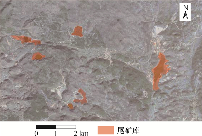
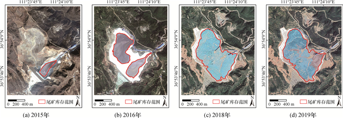
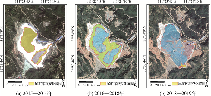
张成业, 邢江河, 李军, 等. 基于U-net网络和GF-6影像的尾矿库空间范围识别[J]. 国土资源遥感, 2021, doi: 10.6046/gtzyyg.2021017
Zhang Chengye, Xing JiangHe, Li Jun, et al. Recognition of the spatial range of tailing ponds based on U-net and GF-6 Image[J]. Remote Sensing for Land and Resources, 2021, doi: 10.6046/gtzyyg.2021017.
|
Figures(14) / Tables(2)


 DownLoad: