


Study on ecological quality evaluation of mining area based on remote sensing green index—Taking Yima mining area as an example
-
摘要: 矿区的开采活动对区域的生态环境质量具有很大影响。为了更加客观准确地评价矿区生态环境质量,构建了一种适用于研究矿区生态环境质量的遥感绿色指数(RSGI)模型,并初次将模型应用于义马矿区的生态环境质量评价。基于1991年、2011年、2021年的Landsat遥感影像,利用ENVI5.3软件对遥感影像进行监督分类、计算遥感绿色指数,从时间和空间上对义马矿区近30年生态环境质量进行评价;并运用皮尔逊相关系数分析了矿区生态环境质量与矿区各生态要素之间的相关性。结果表明:① 1991—2021年总体的生态环境质量以优为主,绿色空间面积均达到80%以上;② 1991年、2011年和2021年义马矿区RSGI数值分别为0.90、0.91和0.89,其生态环境质量呈现先增长后缓慢下降,总体上处于下降趋势;③ 1991—2021年间,生态环境质量变化明显的是城镇以及矿区,大部分城镇和矿区生态环境质量呈现下降趋势,说明义马矿区生态环境质量的变化与矿业开发活动密切相关;④遥感绿色指数高的地方,其耕地、林地、草地所占面积比重比较大,建筑物和不透水表面面积占比较小,遥感绿色指数与各指标之间有显著的相关性。研究结果为义马矿区生态环境修复与绿色矿山建设提供重要的科学依据。Abstract: Mining and development of mining area poses significant impact on regional ecological quality. This study proposed a new remote sensing green index(RSGI)model more tailored for evaluating the ecological quality in the mining area by taking the Yima mining area as an example for analysis. The model was first applied to the ecological quality evaluation of the Yima mining area. Based on Landsat remote sensing images in 1991, 2011 and 2021, ENVI5.3 software was used to supervise the classification of remote sensing images and calculate the green index of remote sensing. The ecological quality of Yima Mining area in the past 30 years was evaluated from the perspective of time and space. Pearson correlation coefficient is used to analyze the correlation between ecological quality and ecological factors in mining area. Results showed that: ① From 1991 to 2021, the overall ecological quality was satisfactory, with the green space area reached more than 80 %. ② In 1991, 2011 and 2021, the RSGI values of Yima mining area were 0.90, 0.91 and 0.89, respectively. The ecological quality of Yima mining area showed initial increase and then a slow decline, and the overall ecological quality exhibits in a downward trend. ③ From 1991 to 2021, there were significant changes of eco-quality in towns and mining areas, with a downward trend observed in most regions. This indicates that the changes of eco-quality in Yima mining area is closely related to mining activities. ④ Areas with high remote sensing green index demonstrate larger proportion of cultivated land, forest land and grassland, and smaller proportion of buildings and impervious surface area. There is a significant correlation between remote sensing green index and other indexes. The research results provide reference for eco-environmental restoration and green mine construction in Yima mining area.
-

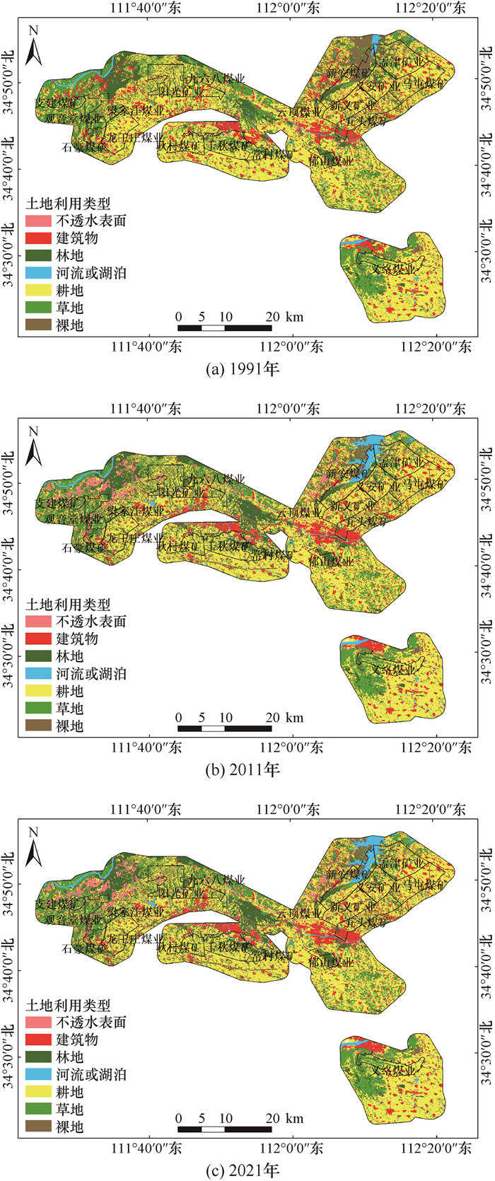
图 2 1991年、2011年、2021年义马矿区土地利用分类
Figure 2. Classification of land use in Yima Mining area in 1991, 2011 and 2021

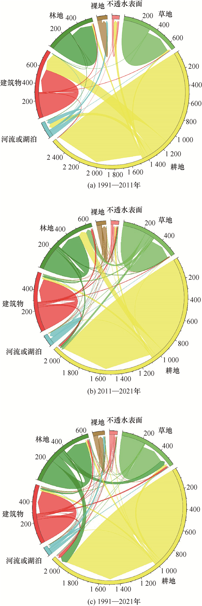
图 3 1991年、2011年、2021年土地利用空间变化
Figure 3. Spatial changes of land use in 1991, 2011and 2021

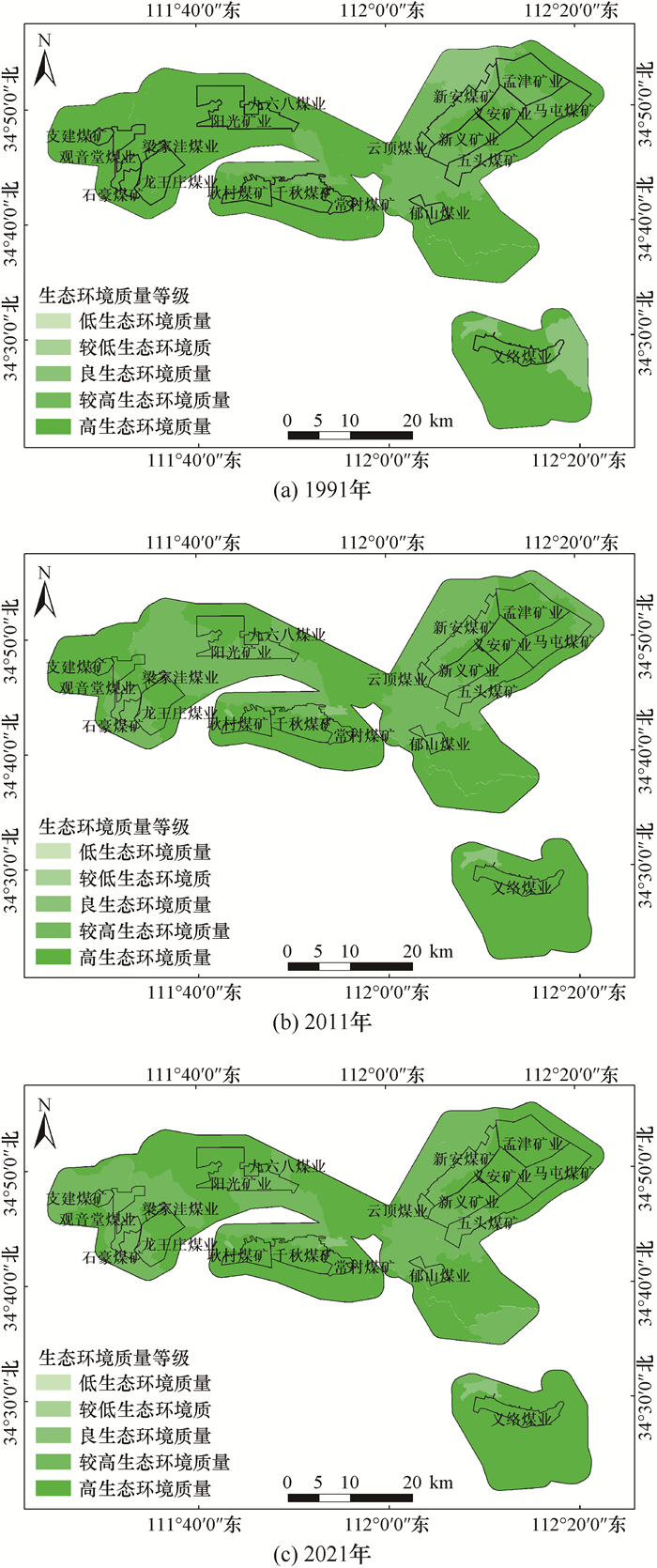
图 4 1991、2011、2021年义马矿区RSGI等级分布
Figure 4. RSGI grade distribution of Yima Mining area in 1991, 2011 and 2021

图 5 1991、2011、2021年RSGI变化极差
Figure 5. Extremely poor RSGI changes in 1991, 2011 and 2021
表 1 生态环境质量等级划分
Table 1. Classification of ecological and environmental quality
生态环境质量等级 遥感绿色指数值范围 低 0.00~0.30 较低 0.30~0.50 良 0.50 ~0.75 较高 0.75~0.90 高 0.90~1.00  下载: 导出CSV
表 2 1991年、2011年、2021年土地利用类型统计
Table 2. Statistics of land use types in 1991, 2011 and 2021
土地利用类型 1991年 2011年 2021年 面积/km2 比例/% 面积/km2 比例/% 面积/km2 比例/% 建筑物 278.18 13.38 281.71 13.55 285.94 13.75 不透水表面 24.35 1.20 24.35 1.18 51.74 2.49 河流或湖泊 31.05 1.50 55.02 2.65 56.38 2.71 草地 328.94 15.82 327.21 15.74 241.51 11.62 林地 270.88 13.03 268.21 12.90 362.15 16.48 耕地 1 076.99 51.80 1 074.33 51.67 1 037.07 50.81 裸地 68.90 3.31 48.66 2.34 44.49 2.14 总计 2 079.29 100.00 2 079.29 100.00 2 079.29 100.00
下载: 导出CSV
表 3 1991—2021年生态环境质量等级面积和比例
Table 3. Area and proportion of ecological and environmental quality grades from 1991 to 2021
RSGI等级 1991年 2011年 2021年 面积/km2 占比/% 面积/km2 占比/% 面积/km2 占比/% 低 3.80 0.18 3.80 0.18 4.76 0.23 较低 0.99 0.04 0.99 0.05 0.00 0.00 良 91.61 4.41 18.32 0.88 18.32 0.88 较高 385.05 18.52 646.59 31.10 709.54 34.12 高 1 597.84 76.85 1 409.59 67.79 1 346.67 64.77
下载: 导出CSV
表 4 生态环境质量等级和面积统计
Table 4. Statistical of ecological environment quality level and area
年份 生态变化类型 变化极差 面积/km2 变化比例/% 总变化/% 1991—2011 生态改善 +2 79.90 3.84 9.72 +1 122.27 5.88 生态不变 0 1 573.81 75.69 75.69 生态退化 -1 179.34 8.63 14.59 -2 123.97 5.96 2011—2021 生态改善 +2 44.26 2.13 6.98 +1 100.80 4.85 生态不变 0 1 308.77 62.94 62.94 生态退化 -1 562.82 27.07 30.08 -2 62.64 3.01 1991—2021 生态改善 +2 79.90 3.84 9.72 +1 122.27 5.88 生态不变 0 1 088.78 52.36 52.36 生态退化 -1 570.95 27.46 37.92 -2 217.39 10.46
下载: 导出CSV
表 5 1991—2021年各指标和RSGI指数的相关系数矩阵
Table 5. Correlation coefficient matrix of each indicator and RSGI index from 1991 to 2021
指标 皮尔逊相关性显著性 RSGI 裸地密度 建筑密度 不透水密度 河流密度 绿色空间密度 RSGI 双尾 1 -0.942 -0.972 -0.985 0.955 0.999* — 0.219 0.150 0.109 0.191 0.027 裸地密度 双尾 -0.942 1 0.994 0.871 -0.999* -0.927 0.219 — 0.069 0.328 0.028 0.245 建筑密度 双尾 -0.972 0.994 1 0.918 -0.998* -0.962 0.150 0.069 — 0.259 0.041 0.177 不透水表面密度 双尾 -0.985 0.871 0.918 1 0.891 -0.992 0.109 0.328 0.259 — 0.300 0.082 河流密度 双尾 0.955 0.999* -0.998* 0.891 1 0.942 0.191 0.028 0.041 0.300 — 0.217 绿色空间密度 双尾 0.999* -0.927 -0.962 -0.992 0.942 1 0.027 0.245 0.177 0.082 0.217 — 注:* 在0.05级别(双尾),相关性显著[26]。
下载: 导出CSV
-
[1] 梁齐云, 苏涛, 张灿, 等. 基于改进遥感生态指数的黄山市生态质量评价研究[J]. 地球物理学进展, 2022, 37(4): 1448-1456. https://www.cnki.com.cn/Article/CJFDTOTAL-DQWJ202204008.htmLiang Qiyun, Su Tao, Zhang Can, et al. Research on ecological quality evaluation of Huangshan City based on improved remote sensing ecological index[J]. Progress in Geophysics, 2022, 37(4): 1448-1456. https://www.cnki.com.cn/Article/CJFDTOTAL-DQWJ202204008.htm [2] 刘栩位, 周启刚, 周浪, 等. 基于RSEI的三峡库区重庆段水土保持生态功能区生态环境质量动态监测[J]. 水土保持研究, 2021, 28(5): 278-286. https://www.cnki.com.cn/Article/CJFDTOTAL-STBY202105039.htmLiu Xuwei, Zhou Qigang, Zhou Lang, et al. RSEI-based dynamic monitoring of ecological quality of the soil and water conservation functional area in the Chongqing section of the Three Gorges Reservoir area[J]. Research of Soil and Water Conservation, 2021, 28(5): 278-286. https://www.cnki.com.cn/Article/CJFDTOTAL-STBY202105039.htm [3] 刘金珍, 刘胜祥, 方芳. 基于遥感技术的淋溪河流域生态环境质量现状研究[J]. 环境科学与技术, 2009, 32(5): 173-178. https://www.cnki.com.cn/Article/CJFDTOTAL-FJKS200905047.htmLiu Jinzhen, Liu Shengxiang, Fang Fang. Ecological environment quality of Linxi River Basin based on remote sensing technology[J]. Environmental Science & Technology, 2009, 32(5): 173-178. https://www.cnki.com.cn/Article/CJFDTOTAL-FJKS200905047.htm [4] 张春桂, 李计英. 基于3S技术的区域生态环境质量监测研究[J]. 自然资源学报, 2010, 25(12): 2060-2071. https://www.cnki.com.cn/Article/CJFDTOTAL-ZRZX201012007.htmZhang Chungui, Li Jiying. Study on regional eco-environmental quality monitoring based on 3S technology[J]. Journal of Natural Resources, 2010, 25(12): 2060-2071. https://www.cnki.com.cn/Article/CJFDTOTAL-ZRZX201012007.htm [5] 潘宁, 王帅, 刘焱序, 等. 土壤水分遥感反演研究进展[J]. 生态学报, 2019, 39(13): 4615-4626. https://www.cnki.com.cn/Article/CJFDTOTAL-STXB201913003.htmPan Ning, Wang Shuai, Liu Yanxu, et al. Advances in soil moisture retrieval from remote sensing[J]. Acta Ecologica Sinica, 2019, 39(13): 4615-4626. https://www.cnki.com.cn/Article/CJFDTOTAL-STXB201913003.htm [6] 吴冠辰, 鲁明星, 郑震. 基于遥感技术的露天铁矿扩帮生态环境现状评价研究[J]. 矿业研究与开发, 2019, 39(5): 115-118. https://www.cnki.com.cn/Article/CJFDTOTAL-KYYK201905023.htmWu Guanchen, Lu Mingxing, Zheng Zhen. Evaluation of ecological environment of open-pit iron mine based on remote sensing technology[J]. Mining Research and Development, 2019, 39(5): 115-118. https://www.cnki.com.cn/Article/CJFDTOTAL-KYYK201905023.htm [7] Jat M K, Garg P K, Khare D. Monitoring and modelling of urban sprawl using remote sensing and GIS techniques[J]. Int J Applied Earth Observation and Geoinformation, 2008, 10(1): 26-43. [8] 邢龙飞, 黄赳, 雷少刚, 等. 锡林浩特市胜利矿区近30年植被覆盖度变化研究[J]. 河南理工大学学报: 自然科学版, 2019, 38(3)61-69. https://www.cnki.com.cn/Article/CJFDTOTAL-JGXB201903009.htmXing Longfei, Huang Jiu, Lei Shaogang, et al. Study on vegetation coverage change of Xilinhot's Shengli mining area in recent 30 years[J]. Journal of Henan Polytechnic University: Natural Science, 2019, 38(3)61-69. https://www.cnki.com.cn/Article/CJFDTOTAL-JGXB201903009.htm [9] 郑优男, 王晓辉, 彭书传. 基于RS与GIS技术分析淮南矿区土地利用变化[J]. 环境工程, 2015, 33(S1): 764-768, 782. https://www.cnki.com.cn/Article/CJFDTOTAL-HJGC2015S1192.htmZheng Younan, Wang Xiaohui, Peng Shuchuan. Land use changes in Huainan mining area based on RS and GIS technology[J]. Environmental Engineering, 2015, 33(S1): 764-768, 782. https://www.cnki.com.cn/Article/CJFDTOTAL-HJGC2015S1192.htm [10] 李方方. 基于多植被指数时空变化的矿区生态环境监测[D]. 焦作: 河南理工大学, 2012. [11] 孙从建, 李晓明, 张文强, 等. 基于遥感信息的吕梁山贫困区生态安全评价[J]. 中国环境科学, 2019, 39(12): 5352-5360. https://www.cnki.com.cn/Article/CJFDTOTAL-ZGHJ201912055.htmSun Congjian, Li Xiaoming, Zhang Wenqiang, et al. Evaluation of ecological security in poverty-stricken region of Lüliang Mountain based on the remote sensing image[J]. China Environmental Science, 2019, 39(12): 5352-5360. https://www.cnki.com.cn/Article/CJFDTOTAL-ZGHJ201912055.htm [12] 徐涵秋. 城市遥感生态指数的创建及其应用[J]. 生态学报, 2013, 33(24): 7853-7862. https://www.cnki.com.cn/Article/CJFDTOTAL-STXB201324027.htmXu Hanqiu. A remote sensing urban ecological index and its application[J]. Acta Ecologica Sinica, 2013, 33(24): 7853-7862. https://www.cnki.com.cn/Article/CJFDTOTAL-STXB201324027.htm [13] 李昊宸, 刘莉, 肖卓棱, 等. 重庆中梁山矿区生态环境质量时空变化分析[J]. 环境科学与技术, 2022, 45(S1): 220-226. https://www.cnki.com.cn/Article/CJFDTOTAL-FJKS2022S1031.htmLi Haochen, Liu Li, Xiao Zhuoleng, et al. Ecological environment quality assessment of Chongqing Zhongliangshan mining area based on remote sensing ecological index[J]. Environmental Science & Technology, 2022, 45(S1): 220-226. https://www.cnki.com.cn/Article/CJFDTOTAL-FJKS2022S1031.htm [14] 胡思汉, 姚玉增, 付建飞, 等. 基于RSEI指数的东北矿区生态质量变化评价: 以辽宁弓长岭区为例[J]. 生态学杂志, 2021, 40(12): 4053-4060. https://www.cnki.com.cn/Article/CJFDTOTAL-STXZ202112030.htmHu Sihan, Yao Yuzeng, Fu Jianfei, et al. Evaluation of ecological quality variation in mining area of Northeast China based on RSEI Index: a case study of Gongchangling District, Liaoning Province[J]. Chinese Journal of Ecology, 2021, 40(12): 4053-4060. https://www.cnki.com.cn/Article/CJFDTOTAL-STXZ202112030.htm [15] 李晶, 李生财, 郭伟, 等. 基于改进遥感生态指数的山西省及煤炭矿区生态环境分析[J]. 金属矿山, 2023(1): 30-39. https://www.cnki.com.cn/Article/CJFDTOTAL-JSKS202301003.htmLi Jing, Li Shengcai, Guo Wei, et al. Ecological environment analysis of Shanxi Province and coal mining areas based on modified remote sensing ecological index[J]. Metal Mine, 2023(1): 30-39. https://www.cnki.com.cn/Article/CJFDTOTAL-JSKS202301003.htm [16] Tang H L, Fang J C, Xie R J, et al. Impact of land cover change on a typical mining region and its ecological environment quality evaluation using remote sensing based ecological index(RSEI)[J]. Sustainability, 2022, 14(19): 12694. [17] Ding X H, Zhao W J, Yan T, et al. Response of ecosystem service value to spatio-temporal pattern evolution of land use in typical heavy industry cities: a case study of Taiyuan city, China[J]. Land, 2022, 11(11): 2035. [18] Li L, Chen Z C, Wang S D. Optimization of spatial land use patterns with low carbon target: a case study of Sanmenxia, China[J]. International Journal of Environmental Research and Public Health, 2022, 19(21): 14178. [19] 范昊明, 蔡强国, 王红闪. 中国东北黑土区土壤侵蚀环境[J]. 水土保持学报, 2004, 18(2): 66-70. https://www.cnki.com.cn/Article/CJFDTOTAL-TRQS200402017.htmFan Haoming, Cai Qiangguo, Wang Hongshan. Condition of soil erosion in phaeozem region of northeast China[J]. Journal of Soil and Water Conservation, 2004, 18(2): 66-70. https://www.cnki.com.cn/Article/CJFDTOTAL-TRQS200402017.htm [20] 赵莎, 郑文武. 基于遥感的衡邵干旱走廊土地利用空间格局演变[J]. 湖北农业科学, 2021, 60(9)50-60. https://www.cnki.com.cn/Article/CJFDTOTAL-HBNY202109010.htmZhao Sha, Zheng Wenwu. Spatial pattern evolution of land utilization in Hengshao drought corridor based on remote sensing[J]. Hubei Agricultural Sciences, 2021, 60(9): 50-60. https://www.cnki.com.cn/Article/CJFDTOTAL-HBNY202109010.htm [21] 王旭东, 姚尧, 任书良, 等. 耦合FLUS和Markov的快速发展城市土地利用空间格局模拟方法[J]. 地球信息科学学报, 2022, 24(1): 100-113. https://www.cnki.com.cn/Article/CJFDTOTAL-DQXX202201009.htmWang Xudong, Yao Yao, Ren Shuliang, et al. A coupled FLUS and Markov approach to simulate the spatial pattern of land use in rapidly developing cities[J]. Journal of Geo-Information Science, 2022, 24(1): 100-113. https://www.cnki.com.cn/Article/CJFDTOTAL-DQXX202201009.htm [22] Da Silva D F, Pivetta K F L, Do Couto H T Z, et al. Indicadores de floresta urbana a partir de imagens aereas multiespectrais de alta resolucao[J]. Scientia Forestalis/Forest Sciences, 2005(67): 88-100. [23] 李秀芝, 徐文靖, 苏俊, 等. 基于灰色-BP神经网络的房价波动预测研究: 以内江市为例[J]. 绿色科技, 2022, 24(6)249-253. https://www.cnki.com.cn/Article/CJFDTOTAL-LVKJ202206064.htmLi Xiuzhi, Xu Wenjing, Su Jun, et al. Prediction of house price fluctuation based on grey-BP neural network—taking Neijiang city as an example[J]. Journal of Green Science and Technology, 2022, 24(6)249-253. https://www.cnki.com.cn/Article/CJFDTOTAL-LVKJ202206064.htm [24] 陈艳拢, 王晓岚, 李恩, 等. CEM的波段选择方法研究及应用[J]. 光谱学与光谱分析, 2020, 40(12): 3778-3783. https://www.cnki.com.cn/Article/CJFDTOTAL-GUAN202012024.htmChen Yanlong, Wang Xiaolan, Li En, et al. Research and application of band selection method based on CEM[J]. Spectroscopy and Spectral Analysis, 2020, 40(12): 3778-3783. https://www.cnki.com.cn/Article/CJFDTOTAL-GUAN202012024.htm [25] Yang Q X, Kang Q K, Huang Q Y, et al. Linear correlation analysis of ammunition storage environment based on Pearson correlation analysis[J]. Journal of Physics: Conference Series, 2021, 1948(1): 5. [26] 乔辛悦, 田国行, 刘文霞, 等. 郑州市景观水体东风渠绿藻水华污染特征及营养盐效应[J]. 山西农业大学学报: 自然科学版, 2017, 37(11): 811-817. https://www.cnki.com.cn/Article/CJFDTOTAL-SXNY201711010.htmQiao Xinyue, Tian Guohang, Liu Wenxia, et al. Contaminative characteristics and nutrient effect of green algae in the landscape waterbody of Dongfeng River in Zhengzhou city[J]. Journal of Shanxi Agricultural University: Natural Science Edition, 2017, 37(11): 811-817. https://www.cnki.com.cn/Article/CJFDTOTAL-SXNY201711010.htm -


 点击查看大图
计量
- 文章访问数: 170
- HTML全文浏览量: 88
- PDF下载量: 43
- 被引次数: 0